
Video ~ NewsBriefRecall @2pm 10-4 April 13, 2026 1:21am

Video ~ NewsHour @3pm 10-4 April 13, 2026 12:22am
Email: newsroom@osazuwaakonedo.news
Banking and Media Consultancy… We Analyze The News
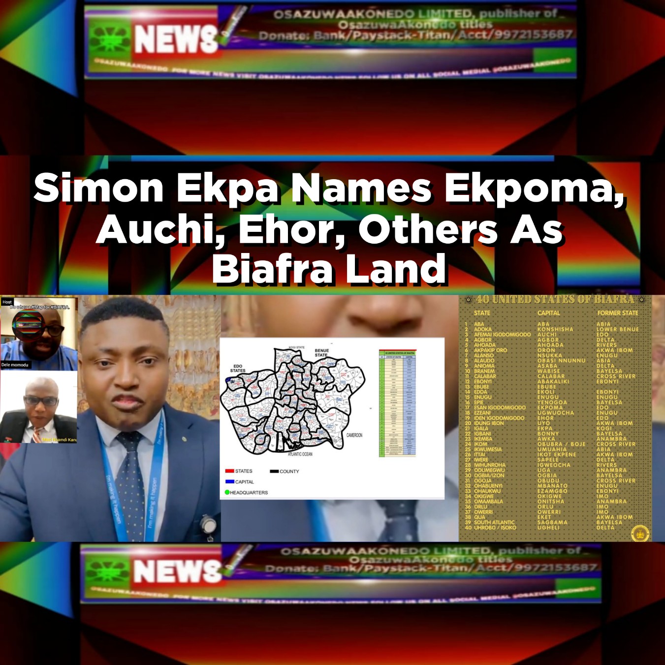
One of the leaders for the agitation and declaration of Biafra Republic from Nigeria and the Prime Minister of Biafra Government in Exile, Simon Ekpa on Tuesday in a video broadcast released the map of the proposed 40 states of Biafra Republic with the declaration and naming of Ekpoma, Auchi and Ehor communities which are the Administrative headquarters of Esan West, Etsako West and Uhunmwonde local government areas of Edo State as Biafra land.
Many historians have agreed that Igbo speaking people dominant in some few communities in Edo State were brought into the communities like Igbanke community often described as “Igbo Akiri” by the detained Leader of Indigenous People of Biafra, IPOB, Nnamdi Kanu as slaves by Bini slave raiders. Meaning, the lands were probably already the ancestral home of Edo People before the 15, 16 centuries when Bini slave raiders brought in people from afar to the border towns.
Nnamdi Kanu in an online interview conducted by Dele Momodu, the founder of Ovation Magazine, years ago before his rearrest by Nigeria Security Operatives said Biafra land starts and ends where women tie two pieces of wrapper.
Nnamdi Kanu refused to be specific about the map of the proposed Biafra Land as requested by the Journalist, Dele Momodu, but insisted that Biafra Land cut across 13 states in Nigeria with specific mentioning of Edo State, Benue State, Kogi State amongst others.
Simon Ekpa while unveiling the proposed map of the Biafra Republic, said, December 2, 2024 have been fixed for referendum. Adding that after the referendum, there maybe more years of battle before the actualization of the Biafra Republic.
In the map and listing of the 40 states of the proposed Biafra Republic, Simon Ekpa named the states, capital cities and former Nigeria states were the Biafra Territories were created from as follow:
40 UnITED StATES Of BiAFRA:
StATE, CaPITAL, FoRMER StATE
1 AbA, AbA, AbIA.
2 AdOKA, KoNSHISHA, LoWER BeNUE.
3 AfEMAI IgODOMIGODO, AuCHI, EdO.
4 AgBOR, AgBOR, DeLTA.
5 AhOADA, AhOADA, RiVERS.
6 AkPAKIP OrO, OrON, AkWA IbOM.
7 AlANSO, NsUKKA, EnUGU.
8 AlAUDO, ObASI NnUNNU, AbIA.
9 AnIOMA, AsABA, DeLTA.
10 BrANEM, WaBISE, BaYELSA.
11 CaLABAR, CaLABAR, CrOSS RiVER.
12 EbONYI, AbAKALIKI, EbONYI.
13 EbUBE, EbUBE.
14 EdDA, EkOLI, EbONYI.
15 EnUGU, EnUGU, EnUGU.
16 EpIE, YeNOGOA, BaYELSA.
17 EsAN IgODOMIGODO, EkPOMA, EDO.
18 EzEANI, UgWUoCHA, EnUGU.
19 IdEN IGODOMIGODO, EhOR, EDO.
20 IdUNG IbON, UyO, AkWA IbOM.
21 IgALA, EkPA, KOGI.
22 IgBANI, BoNNY, BaYELSA.
23 IkEMBA, AwKA, AnAMBRA.
24 IkOM, ObUBRA/BoJE, CrOSS RiVER.
25 IkWUMESIA, UmUAHIA, AbIA.
26 ItTAI, IkOT EkPENE, AkWA IbOM.
27- IwERE, SaPELE, DeLTA.
28 WhUNROHA, IgWEOCHA, RIVERS.
29 OdUMEGWU, UgA, AnAMBRA.
30 OgBIA/IzON, OGBIA, BaYELSA.
31 OgOJA, ObUDU, CrOSS RiVER.
32 OhABUENYI, MbANATO, EnUGU.
33 OhAUKWU, EzAMGBO, EbONYI.
34 OkIGWE, OkIGWE, ImO.
35 OmAMBALA, OnITSHA, AnAMBRA.
36 OrLU, OrLU, ImO.
37 OwERRI, OwERRI, ImO.
38 QuA, EkET, AkWA IbOM.
39 SoUTH AtLANTIC, SaGBAMA, BaYELSA.
40 UhROBO/IsOKO, UgHELI, DeLTA.
That aside, on June 5, 2017, a student historian, simply identified as Omoregie, posted a research project he conducted on the topic: The Origin Of Igbanke People In Edo State” on NairaLand and part of the historical study reads thus: “Igbanke is located in Orhionmwon Local Government Area, Edo state. Igbanke, by name is in Orhionmwon Local Government Area, but geographically, we do not share common boundary with any community in the council.
From the eastern flank, Igbanke shares common boundary with Mbiri, an Ika speaking community in Delta state, from west, it’s bounded by Oghada, another Ika speaking community in Uhunmwode Local Governemnt Area in Edo state.
In the northern sphere, Igbanke has boundary with Ekpon, Ika speaking community in Igueben Local Government Area while from the south, it has Agbor and Oza-Nogogo, Ika communities in Delta state as neighbours. Igbanke is in Edo south senatorial district. Igbanke people and community came under the Bini empire during the latter’s expansionist programme.
Most of other Ika speaking communities that were conquered by Bini empire same time with Igbanke have gotten their independence in Delta state while Igbanke, Oghada, Otobaye, Iru, Ekpon and Ogbeka etc are selfishly scattered in three local government areas”
Another historian posted as documented by Wikipedia that; “Igbanke consists of six villages which came together from the earliest times preceding the slave trade era. The people of Idumodin, Ake, Omolua, Oligie, Ottah, and Igbontor are the villages that came together to establish their settlement which over the years has been referred to as Igbanke”.
Wikipedia captured another historian saying; “The modern borders of Edo State encompasses regions that were formerly the site of various empires and kingdoms of the second dynasty formed in the 11th century AD, the Benin Empire”
Adding; “Edo State borders Kogi State to the north for 133 kilometres and across the Niger River for 81 kilometres to the northeast, Anambra State to the east for about four kilometres across the Niger River, Delta State to the southeast and south for 350 kilometres (218 miles), and Ondo State to the west”.
Simon Ekpa said, December 2, 2024 is the date to present its 40 United States of Biafra Map and issue a declaration.
According to him, this move is to further consolidate the actualisation of Biafra’s independence.
“The Biafra Government is presenting the complete map of Biafra in preparation for the 2nd of December 2024,” he stated.
There are reports that Ekpa recently engaged former United States lawmaker and lobbyist, James Moran, to help convince the US government to support Biafra’s secession from Nigeria.

Osazuwa Akonedo is a Nigerian media professional, author, and consultant. His work spans various sectors of communication and literature: Journalism and Media: He is the founder of OsazuwaAkonedo, which focuses on news analysis and commentary. He also provides consultancy services in media and banking. Literature: He is a published playwright and author of Nigerian literature. One of his notable works is the drama titled The End Shall Tell: What Exam Malpractice Can Cause, which addresses educational and social issues in Nigeria. Reporting: He frequently reports on regional news, particularly concerning Edo State and broader Nigerian current affairs. Credit: Google Gemini AI Mode Osazuwa Akonedo is a Nigerian media creator, journalist, and entrepreneur who engages audiences via news reporting, social media content, music, and a mobile application. Professional Background and Company Osazuwa Akonedo is associated with OSAZUWAAKONEDO LIMITED, a company registered in Nigeria that operates in media consultancy and news services The company is headquartered in Benin City, Edo State, Nigeria, and has been active in publishing news in various formats including text, audio, video, and photos Social Media and Online Platforms Osazuwa Akonedo maintains a strong online presence on several platforms: TikTok: Shares news updates and reports, for example, covering police operations in Nigeria YouTube: Operates a channel where he uploads videos on current affairs and news content Twitter/X: Active under the handle @akonedo_osazuwa, posting updates on events and news Facebook: Profiles listing his connection to news and media activities can be found on Facebook Mobile App: Offers a dedicated mobile application for news access through Google Play (Osazuwa Akonedo News App) providing text, video, and photo news formats News Reporting and Content He produces news content covering national and local stories, including criminal activities, government updates, and investigative reports His reporting spans multiple formats, making it accessible to a wide audience through online platforms, mobile apps, and social media Other Contributions In addition to journalism, Osazuwa Akonedo has also ventured into audio releases, such as “Former Justice Minister Abubakar Malami Begs Nigerians For Justice” released on January 25, 2026 He also hosts podcasts documenting significant events, e.g, NDLEA arrests related to historical criminal cases Summary Osazuwa Akonedo is a multifaceted media professional engaged in journalism, social media content creation, music, and technology via his news app. He utilizes platforms like TikTok, YouTube, Twitter/X, Facebook, and mobile applications to disseminate news and reach audiences both locally and internationally Credit: Azure AI


To view our content, please accept ALL cookies or support us with a donation.
We and our [number_of_vendors] partners use cookies and other tracking technologies to store and access information on your device and to process your personal data.
With your consent, we and our partners may process personal data such as unique identifiers, browsing data, and precise geolocation data, including through device scanning. You can accept or reject all by clicking the buttons below, or customize your choices by clicking "Manage Settings".
Some of our partners process your data based on their legitimate interest. You have the right to object to this processing. You can manage these settings by clicking "Manage Settings" and reviewing the legitimate interest options for each purpose and vendor.
This consent applies to this website only. You can withdraw or change your consent at any time by clicking the floating "Cookie Preferences" button at the bottom-left corner of your screen.
Data Processing Purposes: Store and/or access information on a device (910 seeking consent); Use limited data to select advertising (612 seeking consent, 238 using legitimate interest); Create profiles for personalised advertising (689 seeking consent); Use profiles to select personalised advertising (687 seeking consent); Create profiles to personalise content (299 seeking consent); Use profiles to select personalised content (267 seeking consent); Measure advertising performance (656 seeking consent, 334 using legitimate interest); Measure content performance (326 seeking consent, 143 using legitimate interest); Understand audiences through statistics or combinations of data from different sources (459 seeking consent, 168 using legitimate interest); Develop and improve services (468 seeking consent, 271 using legitimate interest); Use limited data to select content (146 seeking consent, 55 using legitimate interest)
Special Features: Use precise geolocation data; Actively scan device characteristics for identification
Review and customize your consent choices for purposes and vendors. You can grant or withdraw consent for each purpose and vendor individually, or use the buttons below to accept or reject all.
The choices you make regarding the purposes and entities listed in this notice are saved in your browser's localStorage and a cookie named "wpconsent_tcstring" for a maximum duration of 12 months.
These categories are not part of the IAB Transparency & Consent Framework.
Essential cookies enable basic functions and are necessary for the proper function of the website.
AddThis is a social sharing tool that helps websites increase engagement and traffic through easy sharing options.
Azure is Microsoft’s cloud computing platform, offering scalable solutions for storage, analytics, and application development.
Channel.me is a platform for seamless communication and collaboration through organized channels.
CHEQ AI Technologies offers innovative AI solutions to enhance business efficiency and decision-making processes.
Citrix provides virtualization, networking, and cloud solutions for secure remote access and efficient workspace management.
Civic is a decentralized identity verification service that enhances security and privacy for online transactions.
CloudFlare provides web performance and security solutions, enhancing site speed and protecting against threats.
https://osazuwaakonedo.news: developers.cloudflare.com (opens in a new window)
These cookies are needed for adding comments on this website.
Complianz is a comprehensive GDPR, CCPA, and privacy compliance solution for WordPress websites.
Easy Digital Downloads is a WordPress plugin for selling digital products effortlessly and managing transactions.
Google Ads is an online advertising platform that enables businesses to create targeted ads displayed on Google search results and partner sites.
https://osazuwaakonedo.news: policies.google.com (opens in a new window)
Google reCAPTCHA helps protect websites from spam and abuse by verifying user interactions through challenges.
Google Tag Manager simplifies the management of marketing tags on your website without code changes.
These cookies are used for managing login functionality on this website.
Stripe is a payment processing platform that enables businesses to accept online payments securely and efficiently.
https://osazuwaakonedo.news: stripe.com (opens in a new window)
WhatsApp is a messaging app that allows users to send texts, voice messages, and make calls over the internet.
WooCommerce is a customizable eCommerce platform for building online stores using WordPress.
WooCommerce and Jetpack integrate to enhance your online store with powerful features and performance optimization.
A powerful content management system for creating and managing websites easily and efficiently.
WP Consent API is a plugin that standardizes the communication of accepted consent categories between plugins.
WPForms is a user-friendly WordPress plugin for creating custom forms with drag-and-drop functionality.
Zendesk is a customer service platform that streamlines support and enhances customer engagement across channels.
Statistics cookies collect information anonymously. This information helps us understand how visitors use our website.
Abovo Media is a digital marketing agency specializing in data-driven strategies to enhance brand visibility and engagement.
Ezoic is a platform that optimizes website revenue through AI-driven ad placements and analytics.
Google Analytics is a powerful tool that tracks and analyzes website traffic for informed marketing decisions.
https://osazuwaakonedo.news: policies.google.com (opens in a new window)
LinkedIn is a professional networking platform for job seekers, employers, and industry connections.
Mailchimp is an all-in-one marketing platform for email campaigns, automation, and audience management.
Clarity is a web analytics service that tracks and reports website traffic.
https://osazuwaakonedo.news: clarity.microsoft.com (opens in a new window)
OneSignal, Inc. is a U.S. company located at 201 S. B Street, San Mateo, CA 94401 (“OneSignal” “we,” “us,” and “our”). OneSignal is a customer engagement platform for companies around the world to enable their relationships with (and communicate with) their customers. This is primarily done by leveraging first party data (the company’s data on their customers) to personalize and automate messaging by the company through various channels, such as email, SMS, mobile push notifications, web push notifications, and in-app messaging. OneSignal collects this first party data through a software development kit (“ SDKs ”) that companies use in their mobile applications and websites. These web and mobile SDKs permit app developers and website operators to send, manage, optimize and customize messages to their customers and users. All of our services are referred to collectively as our “ Services, ” and the app developers, website operators, business customers, partners and advertisers are referred to collectively as our “ Clients. ”
https://osazuwaakonedo.news: onesignal.com (opens in a new window)
Vimeo is a video hosting platform for high-quality content, ideal for creators and businesses to showcase their work.
https://osazuwaakonedo.news: vimeo.com (opens in a new window)
Wikimedia is a global movement supporting free knowledge through collaborative projects like Wikipedia.
Marketing cookies are used to follow visitors to websites. The intention is to show ads that are relevant and engaging to the individual user.
ActiveCampaign is a marketing automation platform that enhances email marketing, CRM, and customer experience.
Amazon is a leading e-commerce platform offering a vast selection of products, services, and digital content.
Bing, powered by Microsoft, is a search engine providing web, image, video, and map search capabilities.
Dailymotion uses tracking technologies (cookies) to operate its service, enhance user experience, provide tailored content and services, and measure audience engagement. By using the platform, users consent to the cookie policy.
https://osazuwaakonedo.news: legal.dailymotion.com (opens in a new window)
Depending on your actions through our Services or by contacting us through phone or email, you may provide some or all of the following personal information to us, which is required to enable us to fulfil our contract with you (e.g., applicable terms of service) and as otherwise indicated below, by subscribing to or using our Services, creating an account with us, contacting us via our Services or by telephone, text/SMS, email, social media, instant chat, our “contact us” page, or otherwise, including: Contact details, as follows (name, address, phone number, email). If you do not provide this information, we will not be able to provide you with our Services. Account information, as follows (username, password, security questions). If you do not provide this information, we will not be able to provide you with our Services. If you choose to use the Services and register an account, you are responsible for keeping your account credentials safe. We highly recommend that you do not share your username, password, or other access details with anyone else. If you believe your account has been compromised, please contact us immediately. Payment information, as follows (bank account, credit or debit card information, tax ID number, billing address). This information is also required to process your payment for the Services. If you do not provide this information, we will not be able to provide you with our Services. We may collect your Social Security number for the following business purposes: to complete transactions and provide you with Services that you have requested, to comply with any applicable legal obligations, to protect or defend the Services, our rights, the rights of our users, or others, for the purpose of combatting fraud, or to otherwise operate our business. This information is required to enable us to fulfill our contract with you and to process your payment for the Services. If you do not provide this information, we will not be able to provide you with our Services. If you choose to voluntarily provide us with such information, we may collect diversity information, such as your racial or ethnic origin, age, gender, sexual orientation, veteran status, and whether you identify as having a physical or mental disability. We use this information when directed by you and we provide this information to our partners for advertising purposes on your behalf.
https://osazuwaakonedo.news: www.ezoic.com (opens in a new window)
A social media platform for connecting, sharing, and networking with friends and communities worldwide.
Facebook Pixel is a web analytics service that tracks and reports website traffic.
https://osazuwaakonedo.news: www.facebook.com (opens in a new window)
A powerful search engine that organizes and provides access to vast information on the internet.
Monetize your website by displaying targeted ads and earning revenue from clicks and impressions.
Google Flights is a flight search engine that helps users find, compare, and book flights efficiently.
Google Hotel Ads helps hotels reach potential guests with targeted search ads, driving direct bookings and visibility.
Google Maps is a web mapping service providing satellite imagery, real-time navigation, and location-based information.
https://osazuwaakonedo.news: policies.google.com (opens in a new window)
Google Surveys allows businesses to create custom surveys to gather insights and feedback from targeted audiences quickly.
A popular social media platform for sharing photos and videos, connecting users through visual storytelling.
LinkedIn Insight is a web analytics service that tracks and reports website traffic.
https://osazuwaakonedo.news: www.linkedin.com (opens in a new window)
Media.net is a leading ad tech company providing contextual advertising solutions for publishers and advertisers.
Pinterest is a visual discovery platform for sharing and exploring creative ideas through images and links.
Pinterest Tag is a web analytics service that tracks and reports website traffic.
https://osazuwaakonedo.news: policy.pinterest.com (opens in a new window)
A social media platform for discussion, sharing content, and community engagement across various topics and interests.
Smartadserver is a comprehensive ad management platform for publishers and advertisers, optimizing digital advertising campaigns.
A multimedia messaging app for sharing photos, videos, and stories that disappear after viewing.
Taboola is a content discovery platform that recommends articles and videos to engage users across the web.
A social media platform for creating, sharing, and discovering short videos, often featuring music and creative effects.
TikTok Pixel is a tracking tool that measures user interactions and optimizes ad campaigns on the TikTok platform.
https://osazuwaakonedo.news: ads.tiktok.com (opens in a new window)
X, formerly known as Twitter, is a social networking and microblogging platform.
https://osazuwaakonedo.news: x.com (opens in a new window)
X Pixel enables businesses to track user interactions and optimize ad performance on the X platform effectively.
https://osazuwaakonedo.news: x.com (opens in a new window)
Yahoo offers a web portal, search engine, and email services, providing news, finance, and entertainment content.
A video-sharing platform for users to upload, view, and share videos across various genres and topics.
https://osazuwaakonedo.news: www.youtube.com (opens in a new window)
These purposes are part of the IAB Transparency & Consent Framework.
Cookies, device or similar online identifiers (e.g. login-based identifiers, randomly assigned identifiers, network based identifiers) together with other information (e.g. browser type and information, language, screen size, supported technologies etc.) can be stored or read on your device to recognise it each time it connects to an app or to a website, for one or several of the purposes presented here.
Examples:
Most purposes explained in this notice rely on the storage or accessing of information from your device when you use an app or visit a website. For example, a vendor or publisher might need to store a cookie on your device during your first visit on a website, to be able to recognise your device during your next visits (by accessing this cookie each time).
Advertising presented to you on this service can be based on limited data, such as the website or app you are using, your non-precise location, your device type or which content you are (or have been) interacting with (for example, to limit the number of times an ad is presented to you).
Examples:
A car manufacturer wants to promote its electric vehicles to environmentally conscious users living in the city after office hours. The advertising is presented on a page with related content (such as an article on climate change actions) after 6:30 p.m. to users whose non-precise location suggests that they are in an urban zone.
A large producer of watercolour paints wants to carry out an online advertising campaign for its latest watercolour range, diversifying its audience to reach as many amateur and professional artists as possible and avoiding showing the ad next to mismatched content (for instance, articles about how to paint your house). The number of times that the ad has been presented to you is detected and limited, to avoid presenting it too often.
Information about your activity on this service (such as forms you submit, content you look at) can be stored and combined with other information about you (for example, information from your previous activity on this service and other websites or apps) or similar users. This is then used to build or improve a profile about you (that might include possible interests and personal aspects). Your profile can be used (also later) to present advertising that appears more relevant based on your possible interests by this and other entities.
Examples:
If you read several articles about the best bike accessories to buy, this information could be used to create a profile about your interest in bike accessories. Such a profile may be used or improved later on, on the same or a different website or app to present you with advertising for a particular bike accessory brand. If you also look at a configurator for a vehicle on a luxury car manufacturer website, this information could be combined with your interest in bikes to refine your profile and make an assumption that you are interested in luxury cycling gear.
An apparel company wishes to promote its new line of high-end baby clothes. It gets in touch with an agency that has a network of clients with high income customers (such as high-end supermarkets) and asks the agency to create profiles of young parents or couples who can be assumed to be wealthy and to have a new child, so that these can later be used to present advertising within partner apps based on those profiles.
Advertising presented to you on this service can be based on your advertising profiles, which can reflect your activity on this service or other websites or apps (like the forms you submit, content you look at), possible interests and personal aspects.
Examples:
An online retailer wants to advertise a limited sale on running shoes. It wants to target advertising to users who previously looked at running shoes on its mobile app. Tracking technologies might be used to recognise that you have previously used the mobile app to consult running shoes, in order to present you with the corresponding advertisement on the app.
A profile created for personalised advertising in relation to a person having searched for bike accessories on a website can be used to present the relevant advertisement for bike accessories on a mobile app of another organisation.
Information about your activity on this service (for instance, forms you submit, non-advertising content you look at) can be stored and combined with other information about you (such as your previous activity on this service or other websites or apps) or similar users. This is then used to build or improve a profile about you (which might for example include possible interests and personal aspects). Your profile can be used (also later) to present content that appears more relevant based on your possible interests, such as by adapting the order in which content is shown to you, so that it is even easier for you to find content that matches your interests.
Examples:
You read several articles on how to build a treehouse on a social media platform. This information might be added to a profile to mark your interest in content related to outdoors as well as do-it-yourself guides (with the objective of allowing the personalisation of content, so that for example you are presented with more blog posts and articles on treehouses and wood cabins in the future).
You have viewed three videos on space exploration across different TV apps. An unrelated news platform with which you have had no contact builds a profile based on that viewing behaviour, marking space exploration as a topic of possible interest for other videos.
Content presented to you on this service can be based on your content personalisation profiles, which can reflect your activity on this or other services (for instance, the forms you submit, content you look at), possible interests and personal aspects. This can for example be used to adapt the order in which content is shown to you, so that it is even easier for you to find (non-advertising) content that matches your interests.
Examples:
You read articles on vegetarian food on a social media platform and then use the cooking app of an unrelated company. The profile built about you on the social media platform will be used to present you vegetarian recipes on the welcome screen of the cooking app.
You have viewed three videos about rowing across different websites. An unrelated video sharing platform will recommend five other videos on rowing that may be of interest to you when you use your TV app, based on a profile built about you when you visited those different websites to watch online videos.
Information regarding which advertising is presented to you and how you interact with it can be used to determine how well an advert has worked for you or other users and whether the goals of the advertising were reached. For instance, whether you saw an ad, whether you clicked on it, whether it led you to buy a product or visit a website, etc. This is very helpful to understand the relevance of advertising campaigns.
Examples:
You have clicked on an advertisement about a “black Friday” discount by an online shop on the website of a publisher and purchased a product. Your click will be linked to this purchase. Your interaction and that of other users will be measured to know how many clicks on the ad led to a purchase.
You are one of very few to have clicked on an advertisement about an “international appreciation day” discount by an online gift shop within the app of a publisher. The publisher wants to have reports to understand how often a specific ad placement within the app, and notably the “international appreciation day” ad, has been viewed or clicked by you and other users, in order to help the publisher and its partners (such as agencies) optimise ad placements.
Information regarding which content is presented to you and how you interact with it can be used to determine whether the (non-advertising) content e.g. reached its intended audience and matched your interests. For instance, whether you read an article, watch a video, listen to a podcast or look at a product description, how long you spent on this service and the web pages you visit etc. This is very helpful to understand the relevance of (non-advertising) content that is shown to you.
Examples:
You have read a blog post about hiking on a mobile app of a publisher and followed a link to a recommended and related post. Your interactions will be recorded as showing that the initial hiking post was useful to you and that it was successful in interesting you in the related post. This will be measured to know whether to produce more posts on hiking in the future and where to place them on the home screen of the mobile app.
You were presented a video on fashion trends, but you and several other users stopped watching after 30 seconds. This information is then used to evaluate the right length of future videos on fashion trends.
Reports can be generated based on the combination of data sets (like user profiles, statistics, market research, analytics data) regarding your interactions and those of other users with advertising or (non-advertising) content to identify common characteristics (for instance, to determine which target audiences are more receptive to an ad campaign or to certain contents).
Examples:
The owner of an online bookstore wants commercial reporting showing the proportion of visitors who consulted and left its site without buying, or consulted and bought the last celebrity autobiography of the month, as well as the average age and the male/female distribution of each category. Data relating to your navigation on its site and to your personal characteristics is then used and combined with other such data to produce these statistics.
An advertiser wants to better understand the type of audience interacting with its adverts. It calls upon a research institute to compare the characteristics of users who interacted with the ad with typical attributes of users of similar platforms, across different devices. This comparison reveals to the advertiser that its ad audience is mainly accessing the adverts through mobile devices and is likely in the 45-60 age range.
Information about your activity on this service, such as your interaction with ads or content, can be very helpful to improve products and services and to build new products and services based on user interactions, the type of audience, etc. This specific purpose does not include the development or improvement of user profiles and identifiers.
Examples:
A technology platform working with a social media provider notices a growth in mobile app users, and sees based on their profiles that many of them are connecting through mobile connections. It uses a new technology to deliver ads that are formatted for mobile devices and that are low-bandwidth, to improve their performance.
An advertiser is looking for a way to display ads on a new type of consumer device. It collects information regarding the way users interact with this new kind of device to determine whether it can build a new mechanism for displaying advertising on this type of device.
Content presented to you on this service can be based on limited data, such as the website or app you are using, your non-precise location, your device type, or which content you are (or have been) interacting with (for example, to limit the number of times a video or an article is presented to you).
Examples:
A travel magazine has published an article on its website about the new online courses proposed by a language school, to improve travelling experiences abroad. The school’s blog posts are inserted directly at the bottom of the page, and selected on the basis of your non-precise location (for instance, blog posts explaining the course curriculum for different languages than the language of the country you are situated in).
A sports news mobile app has started a new section of articles covering the most recent football games. Each article includes videos hosted by a separate streaming platform showcasing the highlights of each match. If you fast-forward a video, this information may be used to select a shorter video to play next.
You can find more information in our Cookie Policy and Privacy Policy.
Subscribe now to keep reading and get access to the full archive.


